In this article, we’ll learn how GPS works. I feel that it’s important to know how the module we use in our project works, instead of just learning about ‘how to make the module throw its data values at us.’
GPS stands for Global Positioning System and is mainly used to locate the exact location of the receiver with the help of the data it gives (of which the most important are longitude and Latitude coordinates)
1. How does GPS locate a position?
The GPS module works by communicating between the satellites and the GPS receiver module. To locate the position of a place on Earth, we need several parameters like Longitude and Latitude (2-D) and an extra Altitude (for 3-D)
To locate a position in GPS, we use trilateration.
In Two-Dimensional Space:
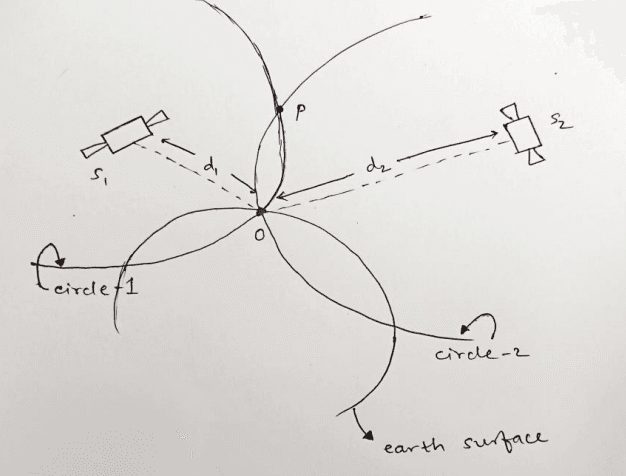
we need a total of 2 satellites (say S1 and S2 here). We are located at point O, and we need to determine our location through GPS.
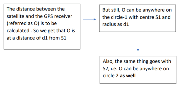
Text version of the above flowchart
Step 1: The distance between the satellite and the GPS receiver (referred to as O) is to be calculated. So we get that O is at a distance of d1 from S1.
Step 2: However, O can be anywhere on circle 1, with center S1 and radius d1.
Step 3: Similarly, O can be anywhere on circle 2.
This implies that O lies in the region common to circle 1 and circle 2. This means it lies at the points of intersection of circles 1 and 2 (here O and P).
To decide between O and P, we consider circle 3, which is the Earth’s surface itself. All the 3 circles intersect at O (therefore, P is eliminated), and hence we obtain the position of a GPS receiver in 2-D.
In Three-Dimensional Space:
We need a total of 3 satellites for locating the position of the GPS receiver
Here, we consider spheres instead of circles.
For quick overview,
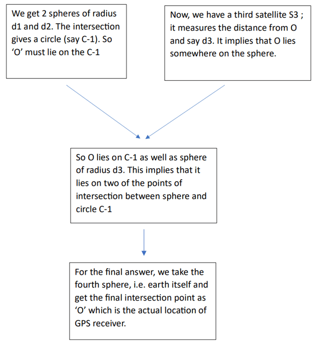
Text version of the above flowchart
Step 1: We have 2 spheres with radii d1 and d2. The intersection gives a circle (say C-1). So ‘O’ must lie on C-1.
Step 2: Now, we have a third satellite, S3; it measures the distance from O as d3. This implies that O lies somewhere on the sphere (of radius d3).
Step 3: So O lies on C-1 as well as on the sphere of radius d3. This means O must be one of the two points of intersection between the sphere of radius d3 and the circle C-1.
Step 4: For the final answer, we take the fourth sphere – Earth itself. The intersection removes the ambiguity and gives the final point as ‘O’,
which is the actual location of the GPS receiver.
But there is a time-delay problem, since the satellites have accurate atomic clocks while GPS receivers use the clocks installed in mobile phones.
But since all the satellites use the same specifications for the atomic clock, the ‘time offset’ is the same. Even a microsecond error can translate into kilometers! Hence, we use the fourth satellite (S4).
As we discussed earlier, we need the distance ‘d’ for locating the positions of satellites.
2. How do We Exactly Determine ‘d’?
The ‘radio signal’ which is sent, it carries 2 information:
- Exact time when it was transmitted (t1)
- Position of the satellite
Now the receiver receives the signal at time t2 (say) :
d=(t1−t2)×cd = (t1 – t2)\times c
where c is the speed of light (3×10⁸m/s)(3 \times 10^{8}\,\text{m/s})
What happens inside the GPS receiver
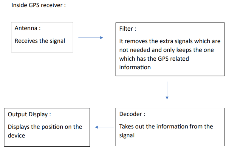
Components involved in GPS (based on the above flowchart):
Antenna: Receives the signal
Filter: Removes extra signals and keeps only the one with GPS-related information.
Decoder: Takes out the information from the signal
Output Display: Displays the position on the device
3. Why is a Fourth Satellite Actually Required?
Earlier, we learned that three satellites can help pinpoint a location in three-dimensional space. However, for a GPS receiver to work effectively, it usually needs signals from at least four satellites.
The main reason for this is that standard GPS receivers don’t have atomic clocks like the satellites do. While GPS satellites have highly precise atomic clocks, devices like smartphones and navigation systems use much simpler and cheaper electronic clocks. Even a tiny timing mistake can lead to a significant error in calculating distances.
For instance, light travels really fast—around 300,000 kilometers per second. So, if the clock in the receiver is off by just one microsecond, it could end up miscalculating the distance by about 300 meters!
In total, a GPS receiver needs to determine four unknowns to accurately figure out its position:
- Latitude (X-coordinate)
- Longitude (Y-coordinate)
- Altitude (Z-coordinate)
- The error in its own clock
With signals from four satellites, the receiver can gather enough information to solve for all these unknowns at the same time. This means that the fourth satellite isn’t just there to make things more accurate; it’s crucial for letting the receiver figure out its clock error.
When the receiver calculates its distance to a satellite, this measurement is called a pseudorange. It’s called that because it initially includes errors from the imperfect clock of the receiver..
4. What Information Does a GPS Satellite Actually Transmit?
A GPS satellite does not simply transmit a signal saying, “I am located here.”
The transmitted radio signal contains several pieces of information that allow the receiver to perform its calculations.
One important part is the satellite’s time information. The receiver needs to know when the signal was transmitted so that it can determine how long the signal took to reach it.
Another important piece of information is the satellite’s orbital information, called ephemeris data.
Ephemeris data provides precise information about the satellite’s orbit, allowing the receiver to calculate where that particular satellite was located when the signal was transmitted.
GPS satellites also transmit information known as the almanac. The almanac contains less precise orbital information about the satellite constellation and helps the receiver determine which satellites should currently be visible.
In simple terms:
Time information → When was the signal transmitted?
Ephemeris → Where exactly was that satellite?
Almanac → Which satellites are expected to be available?
The GPS receiver combines these pieces of information with signals received from several satellites to calculate its own location.
5. Why Does GPS Sometimes Take Time to Find Your Location?
You may have noticed that sometimes GPS can pinpoint your location almost instantly, while at other times it takes a while. This variation is largely due to how much information the GPS receiver already has.
If you’ve been using your GPS recently, it likely remembers where you are, the current time, and which satellites it can connect to. This means it can find the necessary satellites more quickly. On the other hand, if the GPS has been turned off for a long time or has been moved a significant distance while off, it has to gather new satellite information before figuring out where you are.
That’s why you often hear terms like cold start, warm start, and hot start when discussing GPS. In a cold start, the receiver doesn’t have much information, so it has to search for satellites and download the data it needs, which can take some time. Conversely, during a hot start, the receiver already has much of the relevant information, allowing it to determine your position much more quickly.
Modern smartphones can make this process even faster by using data from mobile networks or the internet to help locate your position.
6. Does GPS Require the Internet?
There’s a common misconception that GPS systems require an internet connection to function. In reality, the GPS positioning system itself does not rely on the internet. A phone’s GPS receiver can directly receive signals from satellites to calculate its location independently.
So, why do navigation applications like Google Maps sometimes seem to falter without internet access? The answer lies in the distinction between GPS and map data. GPS technology determines your geographical coordinates, like 19.2183°N, 72.9781°E. These coordinates tell the device where it is located.
However, translating those coordinates into useful visual information—such as roads, buildings, restaurants, traffic data, and place names—requires map data, which is typically accessed online. This is why you may find that your GPS can pinpoint your location, but without an active internet connection, the map application might not function properly.
If you have downloaded the necessary map data for offline use, you can continue to navigate without an internet connection. This means that while GPS helps establish your coordinates, the map application is what provides the context and details needed for navigation.
7. What Affects GPS Accuracy?
While calculating GPS positions might seem simple, the reality is that GPS signals face several challenges before they reach your device.
One of the main issues is the atmosphere. As GPS signals pass through the ionosphere and troposphere, they encounter changes that can slightly delay their travel time. Since GPS works by measuring how long it takes for signals to reach you, even a small delay can lead to errors in distance calculations.
Another common issue is called multipath propagation. Imagine you’re standing in a city surrounded by tall buildings. Instead of the GPS signal traveling straight from the satellite to your phone, it might bounce off a building first. This reflection means the signal takes a longer route, which can result in the receiver calculating a greater distance than the actual space between the satellite and your device. This is why GPS accuracy can decrease in urban areas with lots of tall structures.
Other factors that can impact GPS accuracy include:
– The number of satellites you can see
– The positions of those satellites in the sky
– The presence of walls and buildings
– Weather conditions
– The quality of the GPS receiver
– Any interference with the signal
Having more satellites in view typically helps your GPS get a more accurate position by providing additional measurements.
Keep Learning!